↓
 

Gadsden Land Surveying

...a local Gadsden Land Surveyor.

Gadsden Land Surveying
  • Home
  • ALTA Survey
  • Boundary Surveying
  • Construction Survey
  • Drone LiDAR Mapping
  • Elevation Certificate
  • Land Surveying
  • Topographic Survey
  • Etowah County, AL
    • Gadsden, AL
    • Attalla, AL
    • Boaz, AL
    • Glencoe, AL
    • Hokes Bluff, AL
    • Rainbow City, AL
    • Southside, AL
  • Calhoun County, AL
    • Oxford, AL
    • Alexandria, AL
    • Anniston, AL
    • Jacksonville, AL
    • Ohatchee, AL
    • Piedmont, AL
    • Weaver, AL
    • Wellington, AL
  • St. Clair County, AL
    • Ashville, AL
    • Pell City, AL
    • Leeds, AL
    • Moody, AL
    • Odenville, AL
    • Ragland, AL
    • Riverside, AL
    • Steele, AL
    • Trussville, AL
  • Blog
  • Contact Us
Home 1 2 3 … 6 7 >>

Post navigation

← Older posts

Welcome to Gadsden Land Surveying

Gadsden Land Surveying Posted on February 18, 2017 by Gadsden Land SurveyorApril 2, 2020

This site is intended to provide you with information on Land Surveying in the Gadsden, AL and Etowah County area of Alabama. If you’re looking for a Gadsden Land Surveyor, you’ve come to the right place. If you’d rather talk to someone about your land surveying needs, please call our local number at (256) 952-4711 today. For more information, please continue to read.

gadsden land surveyingLand Surveyors are professionals who make precise measurements to determine the size and boundaries of a piece of real estate.  While this is a simplistic definition, boundary surveying is one of the most common types of surveying related to home and land owners. If you fall into the following categories, please click on the appropriate link for more information on that subject:

Gadsden Land Surveying services:

    1. I need to know where my property corners or property lines are. (Boundary Survey)
    2. I have a loan closing or re-finance coming up on my home in a subdivision. (Lot Survey)
    3. I need a map of my property with contour lines to show elevation differences for my architect or engineer. (Topo Survey)
    4. I’ve just been told I’m in a flood zone or I’ve been told I need an elevation certificate in order to obtain flood insurance or prove I don’t need it. (Flood Survey)
    5. I’m purchasing a lot/house in a recorded subdivision. (Lot Survey – See Boundary Survey)
    6. I’m purchasing a larger tract of land, acreage, that hasn’t been subdivided in the past. (Boundary Survey)

Contact us for Gadsden Land Surveying services TODAY at (256) 952-4711.

Posted in alta survey, boundary surveying, elevation certificate, flood survey, land surveying, land surveyor, lot survey, property survey, topographic survey | Tagged Gadsden AL Land Surveyor, Gadsden Land Surveying, land surveyor

Thinking About a Boundary Survey? Read This First

Gadsden Land Surveying Posted on June 5, 2026 by Gadsden Land SurveyorMay 31, 2026
Surveyor conducting a boundary survey near residential homes to confirm property lines

A boundary survey is one of those things most people only think about when something goes wrong. A neighbor puts up a fence. A contractor needs a permit. A deal falls through at closing. Suddenly, the exact location of a property line matters more than it ever did before.

If you are considering getting one, here is everything you need to know before you pick up the phone.

What a Boundary Survey Actually Does

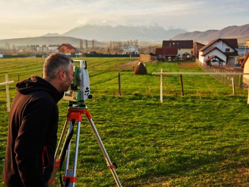
A boundary survey gives you the legal location of your property lines. A licensed land surveyor visits your property, reviews historical deed records and prior plats, takes precise measurements, and produces a signed document showing exactly where your land begins and ends.

That document is called a plat. It carries legal weight. Courts, lenders, title companies, and local governments all accept it as the official record of your property boundaries.

What it shows:

  • The exact location of each property corner
  • The measured distances between corners
  • Any encroachments, meaning structures or fences that cross your boundary line
  • Easements, such as utility lines or access routes that run through your property
  • The relationship between your boundary and neighboring parcels

One thing worth knowing: a boundary survey is not the same as a mortgage survey. A mortgage survey is a basic location sketch used by lenders to confirm what is described in a deed. It is not legally binding and cannot be used for construction, permitting, or resolving disputes. If you need legal certainty about your property lines, a full boundary survey is what you need.

When Do You Actually Need One?

You do not need a boundary survey every few years. Most homeowners only need one when a specific situation calls for it. Common reasons include:

Before building a fence. Many neighbor disputes start because someone assumed where the property line was. A boundary survey removes the guesswork before anything goes in the ground.

Before adding a structure. Sheds, garages, pools, and home additions must meet local setback requirements. Those setbacks are measured from your actual property line, not from where your fence sits or where you think the line is.

When buying land. A prior survey done for a previous owner may be outdated or inaccurate. If you are purchasing property, having a current boundary survey gives you a clear picture of what you are actually buying.

When a property line is disputed. If a neighbor questions where the line falls, a licensed survey is the only document with legal standing to settle it.

When applying for certain permits. Some municipalities require a current boundary survey as part of the permitting process for new construction.

How Much Does a Boundary Survey Cost?

In Alabama, a standard residential boundary survey typically costs between $500 and $1,500. That range covers most single-family lots. Larger properties, rural acreage, heavily wooded land, and parcels with complex boundary histories will cost more.

Nationally, the average runs between $500 and $1,200 for a residential lot under one acre, with surveyors billing at $220 to $450 per hour for their time in the field and office.

Several things affect the final price:

Lot size. More land takes more time to survey. Larger parcels generally cost more.

Shape. A rectangular lot with four clean corners is straightforward. An irregular lot with many sides, angles, or curves takes longer.

Terrain. Wooded, sloped, or hard-to-access land adds field time and difficulty.

Prior records. If a recent, accurate survey already exists for the property, a surveyor can use it as a starting point. If no prior survey exists, or if the old one is unreliable, research takes longer and costs more.

Missing corners. When original property corners have been removed, buried, or disturbed over the years, the surveyor has to reconstruct their location from surrounding evidence. That adds time.

The best way to get a realistic number is to contact a licensed surveyor directly. Give them your address, parcel ID, approximate lot size, and the reason you need the survey. Most will provide an estimate from there.

What Happens During the Survey Process?

Most residential boundary surveys take one to three weeks from scheduling to final delivery. The process has three main stages.

First, the surveyor does records research. This means pulling your deed, reviewing any prior plats, and looking at historical documents that help establish where your boundary lines were originally set. This happens before anyone sets foot on the property.

Second, the survey crew visits your property. They locate existing corner markers, take field measurements, and document any improvements, fences, or encroachments. This typically takes one to two days for a standard residential lot.

Third, the office work begins. The field data is processed, calculations are checked, and the final plat is drafted. Once it is reviewed and signed by the licensed surveyor, it is delivered to you as your official legal document.

Who Can Legally Perform a Boundary Survey?

In Alabama, only a licensed Professional Land Surveyor can legally establish or re-establish property boundaries. That is not a formality. It is a requirement under state law.

An unlicensed survey has no legal standing. It cannot be used for permits, real estate transactions, or court proceedings.

Before hiring anyone, ask to see their current PLS license. You can also verify a surveyor’s license through the Alabama State Board of Licensure for Professional Engineers and Land Surveyors at albels.alabama.gov.

A few other things worth confirming before you hire:

  • They carry professional liability insurance, sometimes called errors and omissions coverage
  • They will provide a written scope of work and a fee estimate before starting
  • The final plat will be signed and sealed by the licensed surveyor of record

Frequently Asked Questions

Will the surveyor mark my corners with stakes? 

Yes. A standard boundary survey includes physical corner markers, usually iron rods, placed at each property corner. These give you visible reference points on the ground.

Can I use a county GIS map or an online tool to find my property lines? 

Those tools can give you a rough estimate, but they are not legally binding and are often inaccurate at the parcel level. They are useful for general reference, but they are not a substitute for a licensed boundary survey.

Does a boundary survey expire? 

There is no set expiration date, but a survey can become outdated if property conditions change, new improvements are added, or boundaries are altered. If your existing survey is more than ten to fifteen years old and you are planning construction or a sale, it is worth having a licensed surveyor assess whether a new one is needed.

What is the difference between a boundary survey and a property survey? 

These terms are often used interchangeably in everyday conversation. Technically, “property survey” is a broader term that can refer to several types, including mortgage surveys and topographic surveys. When you need legal boundary lines confirmed, ask specifically for a boundary survey.

Posted in boundary surveying | Tagged boundary survey, boundary surveying

What Is a Topographic Survey And Who Actually Needs One?

Gadsden Land Surveying Posted on June 3, 2026 by Gadsden Land SurveyorMay 31, 2026
Aerial view of a property with contour lines and elevation data from a topographic survey

A topographic survey is a detailed map of a piece of land. It shows the shape of the ground, including hills, slopes, flat areas, and low spots. It also shows trees, streams, buildings, roads, and other features. This type of survey gives builders, engineers, and architects a clear picture of what the land looks like before they start any project.

What Does a Topographic Survey Show?

Most people have seen a basic property map. A topographic survey gives much more information than that. It measures the land at many different points and uses that data to create a three-dimensional picture of the ground.

Here is what a topographic survey typically includes:

  • Elevation and contour lines that show how high or low the land is at different spots
  • Slopes and grades that tell you how steep the land is
  • Natural features like trees, streams, ponds, and hills
  • Man-made structures such as buildings, fences, roads, and utility lines
  • Water flow patterns showing where rain and runoff naturally travel across the land

This information is important because it helps people plan ahead. It shows not just where a property ends, but what the ground actually looks like across the whole area.

How Is It Different From a Boundary Survey?

A boundary survey shows where your property lines are. It answers the question, “Where does my land begin and end?”

A topographic survey answers a different question: “What does the land look like?”

Both types of surveys are useful, and they are sometimes done together on the same project. But they are not the same thing. If you want to know your property lines or settle a dispute with a neighbor, you need a boundary survey. If you want to build, grade, or fix a drainage problem, you need a topographic survey.

How Does a Topographic Survey Work?

The process has four main steps.

Step 1: Planning 

The surveyor figures out the goal of the survey, how big the area is, and how much detail is needed. They also look at any existing records about the land.

Step 2: Measuring the Land 

Surveyors go out to the property and take measurements. They use tools like GPS receivers and total stations to record hundreds of points across the land. For bigger properties, surveyors sometimes use drones. Drones with special laser equipment can cover more than 500 acres in a single day, which is much faster than walking the land on foot.

Step 3: Processing the Data 

Back at the office, the surveyor uses computer software to turn all those measurements into maps and models. This includes contour maps that show the shape of the land.

Step 4: Delivering the Final Map 

The surveyor gives the client a finished topographic map. Depending on the project, this may also include cross-sections and elevation details that builders or engineers need to move forward.

Who Actually Needs a Topographic Survey?

Not everyone needs one. But for the right project, getting a topographic survey early can save a lot of time, money, and trouble later on.

Homeowners Who Want to Build or Make Changes

If you are building a new home, adding a room, putting in a retaining wall, or doing any work that changes the shape of your yard, a topographic survey is often required. In many areas, the law says the lowest floor of a building must be above a certain flood level. Without knowing the exact elevation of your land, your builder or architect cannot make sure the design follows that rule.

Developers and Engineers

Anyone developing land needs accurate ground data. Engineers use topographic surveys to plan how dirt will be moved, how water will drain, and where structures should go. Many local governments also require a topographic map before they will approve permits for grading, stormwater systems, or new construction.

Property Owners Near Water or in Flood Zones

If your property is near a river, pond, or low-lying area, a topographic survey can be very helpful. It shows exactly how the land sits and where water is likely to flow during heavy rain. This information helps engineers design the right drainage systems and helps homeowners understand their flood risk.

Architects and Site Planners

Architects need to know what the ground looks like before they design a building. A topographic survey helps them figure out where to place the building, how to handle water runoff, and how to work with the natural shape of the land instead of fighting against it.

When Do You Need One?

A topographic survey makes sense in these situations:

  • Before any new construction starts, so builders have the information they need from the beginning
  • Before applying for permits, since many counties and cities require elevation data as part of the application
  • When water drainage is a problem, because even a small mistake in elevation can cause flooding or pooling once a project is finished
  • When planning a subdivision or large development, to check if the land is a good fit for the project

How Much Does a Topographic Survey Cost?

The cost depends on the size of the property, how complex the terrain is, and what method is used to do the survey.

For a home lot under one acre, a topographic survey usually costs between $2,000 and $3,500. Larger or harder-to-measure properties can cost between $2,000 and $6,500 or more. Drone surveys can lower the cost on bigger properties. A 20-acre site that costs $15,000 to $30,000 with traditional methods can often be done for $3,000 to $6,000 using drones, which is a savings of 50 to 75 percent.

If your land already has a topographic survey that is less than five years old and nothing major has changed, a surveyor may be able to update it instead of starting over. Updating an existing survey can save you 30 to 50 percent.

Posted in land surveying | Tagged topographic survey

What Is an ALTA Survey and When Do You Need One?

Gadsden Land Surveying Posted on June 1, 2026 by Gadsden Land SurveyorMay 31, 2026
Surveyor and commercial property investor reviewing an ALTA land survey and site plan before a real estate transaction

If you are buying a commercial property or working with a lender on a real estate deal, you have probably heard the term ALTA survey. Most people have no idea what it means. 

What Is an ALTA Survey?

An ALTA survey is the most detailed property survey you can get in the United States. It maps out a property’s boundaries, buildings, easements, and anything else that could affect who owns what and how the land can be used.

The name comes from the American Land Title Association, or ALTA. This group worked with the National Society of Professional Surveyors (NSPS) to create a single set of rules that all licensed surveyors must follow when completing this type of survey. Those rules are called the Minimum Standard Detail Requirements.

Because every surveyor follows the same rules, a lender in Texas will accept an ALTA survey from Florida without question. That consistency is exactly why banks, title companies, and attorneys trust this survey above all others.

The current rules took effect on February 23, 2021. A new update went into effect on February 23, 2026. ALTA and NSPS update their standards every five years to keep up with changes in the industry.

What Does an ALTA Survey Include?

Every ALTA survey must show the following:

  • The property’s boundary lines and corners
  • The location of all buildings and structures on the land
  • All easements and rights-of-way listed in the title commitment
  • Any encroachments from or onto neighboring properties
  • All access points to and from public roads
  • The legal description of the property
  • A signed and sealed certification from a licensed surveyor

What Are Table A Items?

Clients and lenders can also request extra details called Table A items. These are optional add-ons that go beyond the basics. Common examples include:

  • Flood zone classification
  • Location of above-ground utilities
  • Zoning classification and setback requirements
  • Topographic data and site elevations
  • Parking layout and counts
  • Square footage of buildings and total land area

Your lender or title company will tell you which Table A items they need. Each one added to the survey increases the level of detail and the final cost.

When Do You Need an ALTA Survey?

Buying or refinancing commercial property. Almost every commercial real estate transaction in the United States requires an ALTA survey. Lenders need it to confirm the property lines, check the legal description, and spot any problems before the deal closes.

Your lender or title company asks for one. If they require it, there is no way around it. A basic boundary survey will not meet their standards.

The property has a complicated history. If there are old easements, boundary disputes, or unclear descriptions in the records, an ALTA survey clears things up before they become your problem after closing.

You are developing or investing in property. Developers buying land for new construction use an ALTA survey as the foundation for site planning, engineering, and zoning applications. Investors buying apartment buildings, office spaces, or shopping centers also rely on them to map out shared spaces, parking areas, and tenant boundaries.

ALTA Survey vs. Boundary Survey

A boundary survey marks property lines. It works fine for most homes. An ALTA survey does everything a boundary survey does, plus much more. It is the only type of survey that lenders and title companies accept for commercial transactions.

FeatureBoundary SurveyALTA Survey
Follows national standardsNoYes
Documents easementsSometimesAlways
Notes encroachmentsSometimesAlways
Maps utilitiesNoOptional
Accepted by lendersRarelyYes
Typical cost$500 – $2,000$2,500 – $15,000+

How Much Does an ALTA Survey Cost?

Property TypeTypical Cost
Small urban parcel (under 1 acre)$1,000 – $3,500
Suburban commercial lot (1 – 5 acres)$2,500 – $6,000
Larger parcel (5 – 25 acres)$5,000 – $12,000
Rural or complex site (25+ acres)$10,000 – $30,000+

A few things that affect the final price:

  • Property size and shape. Larger and more irregular parcels take more time to survey.
  • Number of Table A items. Each optional item adds to the scope and the cost.
  • Available records. If old surveys and title documents are easy to find, the surveyor spends less time on research.
  • Rush delivery. If you need the survey in five to seven business days instead of the standard two to four weeks, expect to pay 25 to 50 percent more.

Getting quotes from more than one licensed surveyor can lower your cost by 15 to 30 percent. Sharing any existing survey records or title documents with your surveyor upfront also helps cut down on research time.

Why ALTA Surveys Matter for Title Insurance

When you buy title insurance, the policy usually includes something called a survey exception. This means the insurance does not cover any boundary problems or encroachments that a survey would have found. In other words, if there is a problem with the property lines and no survey was done, you are on your own.

When a title company receives an acceptable ALTA survey, it can remove that exception. That means your policy covers more, and both you and your lender are better protected.

This is the main reason lenders require an ALTA survey for commercial deals. They want a title policy with no gaps in coverage.

Frequently Asked Questions

Do I need an ALTA survey for a regular home purchase? 

Usually not. Most home loans only require a standard boundary survey or mortgage location survey. The exception is if the home is a high-value property, a multi-unit building, or has a complicated title history.

Can I use an old ALTA survey? 

Sometimes. Most lenders and title companies want a survey that is no more than six months to one year old at the time of closing. If the property has changed since the last survey was done, it will need to be updated.

Who is allowed to prepare an ALTA survey? 

Only a licensed land surveyor who holds an active license in the state where the property is located. The finished survey must include the surveyor’s signature, seal, and the date it was certified. Always choose a surveyor with experience in ALTA surveys specifically, not just general boundary work.

Posted in alta survey | Tagged alta survey

Post navigation

← Older posts

Search This Site

Get Quote Button
© Gadsden Land Surveying by Tucker Engineering, LLC
3331 Rainbow Drive, Suite E, #151
Rainbow City, Alabama 35906
Phone: (256) 952-4711

Web Development and SEO by:
N2Biz.co


Privacy Policy | Terms of Use

↑