
What Is a Topographic Survey And Who Actually Needs One?
A topographic survey is a detailed map of a piece of land. It shows the shape of the ground, including hills, slopes, flat areas, and low spots. It also shows trees, streams, buildings, roads, and other features. This type of survey gives builders, engineers, and architects a clear picture of what the land looks like before they start any project.
What Does a Topographic Survey Show?
Most people have seen a basic property map. A topographic survey gives much more information than that. It measures the land at many different points and uses that data to create a three-dimensional picture of the ground.
Here is what a topographic survey typically includes:
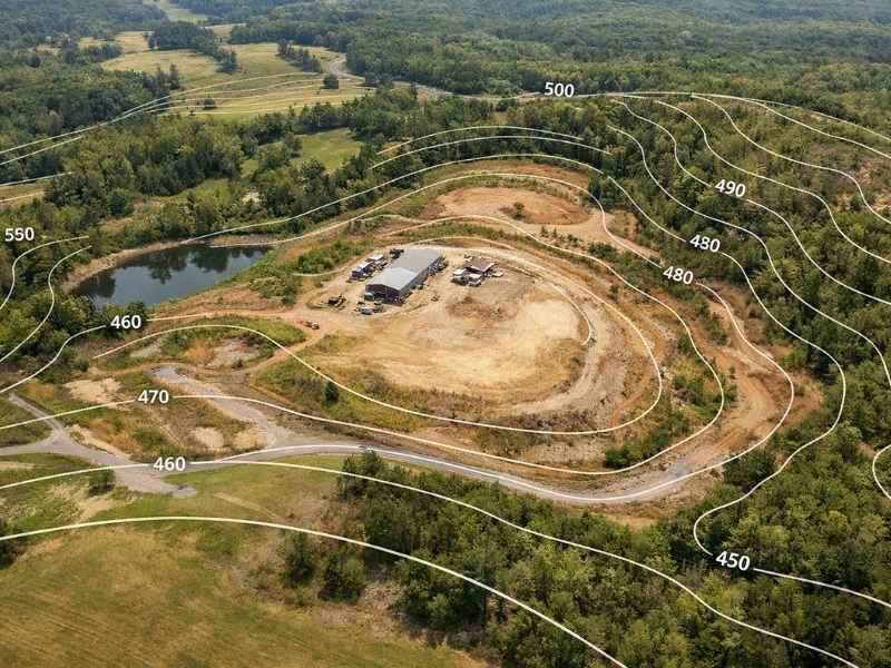
- Elevation and contour lines that show how high or low the land is at different spots
- Slopes and grades that tell you how steep the land is
- Natural features like trees, streams, ponds, and hills
- Man-made structures such as buildings, fences, roads, and utility lines
- Water flow patterns showing where rain and runoff naturally travel across the land
This information is important because it helps people plan ahead. It shows not just where a property ends, but what the ground actually looks like across the whole area.
How Is It Different From a Boundary Survey?
A boundary survey shows where your property lines are. It answers the question, “Where does my land begin and end?”
A topographic survey answers a different question: “What does the land look like?”
Both types of surveys are useful, and they are sometimes done together on the same project. But they are not the same thing. If you want to know your property lines or settle a dispute with a neighbor, you need a boundary survey. If you want to build, grade, or fix a drainage problem, you need a topographic survey.
How Does a Topographic Survey Work?
The process has four main steps.
Step 1: Planning
The surveyor figures out the goal of the survey, how big the area is, and how much detail is needed. They also look at any existing records about the land.
Step 2: Measuring the Land
Surveyors go out to the property and take measurements. They use tools like GPS receivers and total stations to record hundreds of points across the land. For bigger properties, surveyors sometimes use drones. Drones with special laser equipment can cover more than 500 acres in a single day, which is much faster than walking the land on foot.
Step 3: Processing the Data
Back at the office, the surveyor uses computer software to turn all those measurements into maps and models. This includes contour maps that show the shape of the land.
Step 4: Delivering the Final Map
The surveyor gives the client a finished topographic map. Depending on the project, this may also include cross-sections and elevation details that builders or engineers need to move forward.
Who Actually Needs a Topographic Survey?
Not everyone needs one. But for the right project, getting a topographic survey early can save a lot of time, money, and trouble later on.
Homeowners Who Want to Build or Make Changes
If you are building a new home, adding a room, putting in a retaining wall, or doing any work that changes the shape of your yard, a topographic survey is often required. In many areas, the law says the lowest floor of a building must be above a certain flood level. Without knowing the exact elevation of your land, your builder or architect cannot make sure the design follows that rule.
Developers and Engineers
Anyone developing land needs accurate ground data. Engineers use topographic surveys to plan how dirt will be moved, how water will drain, and where structures should go. Many local governments also require a topographic map before they will approve permits for grading, stormwater systems, or new construction.
Property Owners Near Water or in Flood Zones
If your property is near a river, pond, or low-lying area, a topographic survey can be very helpful. It shows exactly how the land sits and where water is likely to flow during heavy rain. This information helps engineers design the right drainage systems and helps homeowners understand their flood risk.
Architects and Site Planners
Architects need to know what the ground looks like before they design a building. A topographic survey helps them figure out where to place the building, how to handle water runoff, and how to work with the natural shape of the land instead of fighting against it.
When Do You Need One?
A topographic survey makes sense in these situations:
- Before any new construction starts, so builders have the information they need from the beginning
- Before applying for permits, since many counties and cities require elevation data as part of the application
- When water drainage is a problem, because even a small mistake in elevation can cause flooding or pooling once a project is finished
- When planning a subdivision or large development, to check if the land is a good fit for the project
How Much Does a Topographic Survey Cost?
The cost depends on the size of the property, how complex the terrain is, and what method is used to do the survey.
For a home lot under one acre, a topographic survey usually costs between $2,000 and $3,500. Larger or harder-to-measure properties can cost between $2,000 and $6,500 or more. Drone surveys can lower the cost on bigger properties. A 20-acre site that costs $15,000 to $30,000 with traditional methods can often be done for $3,000 to $6,000 using drones, which is a savings of 50 to 75 percent.
If your land already has a topographic survey that is less than five years old and nothing major has changed, a surveyor may be able to update it instead of starting over. Updating an existing survey can save you 30 to 50 percent.