↓
 

Gadsden Land Surveying

...a local Gadsden Land Surveyor.

Gadsden Land Surveying
  • Home
  • ALTA Survey
  • Boundary Surveying
  • Construction Survey
  • Drone LiDAR Mapping
  • Elevation Certificate
  • Land Surveying
  • Lot Survey – Closing Survey
  • Topographic Survey
  • Etowah County, AL
    • Gadsden, AL
    • Attalla, AL
    • Boaz, AL
    • Glencoe, AL
    • Hokes Bluff, AL
    • Rainbow City, AL
    • Southside, AL
  • Calhoun County, AL
    • Oxford, AL
    • Alexandria, AL
    • Anniston, AL
    • Jacksonville, AL
    • Ohatchee, AL
    • Piedmont, AL
    • Weaver, AL
    • Wellington, AL
  • St. Clair County, AL
    • Ashville, AL
    • Pell City, AL
    • Leeds, AL
    • Moody, AL
    • Odenville, AL
    • Ragland, AL
    • Riverside, AL
    • Steele, AL
    • Trussville, AL
  • Contact Us
Home - Page 5 << 1 2 3 4 5 6 >>

Post navigation

← Older posts
Newer posts →

Can Engineering Flood Study Help Your Neighborhood?

Can an Engineering Flood Study Help Your Neighborhood?
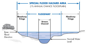
flood zone | flood surveyA recent article in the Allied News in Grove City, Pennsylvania reminded me of the Engineering Flood Studies that I have completed over the years and how these have helped the neighborhoods adjacent to the streams that were studied.

“FEMA says it does allow the municipalities to pay for their own engineering study to prove that areas along Wolf Creek are no longer affected by flooding since dams were taken out.”

Not only are flood studies useful when conditions change, like a dam being taken out, but for the following conditions:

  • A stream has never had a detailed flood study completed (called Zone “A”)
  • Contemplation of widening a ditch to handle the flood waters within it
  • Proving that a stream Base Flood Elevation (BFE) and flood hazard zone are incorrectly shown

Every Stream Has a Base Flood Elevation

The fact about flood zones that most people don’t realize is that EVERY stream has an elevation that it will rise to given a certain amount of rainfall. The more rainfall, the higher flood waters will rise. So, when an area receives the 1% chance storm (formerly called the 100-year storm), you will see the flood waters rise to a level called the Base Flood Elevation (BFE). And, again, every stream has a Base Flood Elevation.

So, if you live by a dry ditch, an intermittent stream, or a year-round flowing creek, you should be aware of the Base Flood Elevation of that stream. So, FEMA doesn’t “PUT” you in a flood zone. They only map the flood hazard of more and more streams each time, and “SHOW” you in the flood zone that you were already in. There are also instances where development has occurred since the previous flood maps were created and your area has experienced an increase in the flood elevation because of the change in the amount and speed of the runoff.

Estimated Flood Zone “A”

The most common areas that are in need of a flood study are those estimated flood zone “A” areas on the flood maps. This means that a “detailed study” hasn’t been done for that area and the flood zone is estimated based on contour maps of the area. It is difficult for insurance companies and surveyors to determine your risk in these areas because we don’t have an elevation to use to compare to your home elevation.

The steps for an Engineered Flood Study are:

  1. Determine the length of the stream to study. This can be 500 to 5000 feet or more.
  2. Collect cross-sections of the stream. This gives the shape of the stream bed which tells us how much water can move through the stream and how far outside the banks the flood water will come.
  3. Determine the drainage area for the stream. This is done using contour maps of the area.
  4. Estimate the runoff coefficients for the drainage basin. This is not easy to accurately estimate and this step is where lots of variance is built into the equations.
  5. Use the data collected and an approved method and software program to determine the base flood elevation.
  6. Submit the findings to FEMA for concurrence and approval.

As I said in one of the steps, drainage calculations are only estimates. All of the approved methods and formula have a certain amount of variance in them. Most methods are from 65% to 85% accurate. This is based on the many types of soil, vegetation, and ground cover that occurs within the drainage basin, and the estimates used in the amount of rainfall and runoff that occurs.
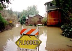
flood survey | flood study | flood zoneThis is why most flood ordinances require that new homes are built at least one to two feet above the BFE. And, it’s the reason that I always recommend that you get flood insurance if you are close to a stream, even if you are shown as being OUT of the flood hazard zone. The insurance policy is cheapest in that situation. And, flooding over the 1% storm happens all the time. Consider it similar to your homeowners insurance which covers fire damage.

References: Trends in Floods,  and The Human Impact of Floods
If you have questions about a flood study, or any other flood elevation questions, call Gadsden Land Surveying at (256) 952-4711.

Posted on September 25, 2017 by Gadsden Land SurveyorApril 2, 2020

Land Surveying: Ethics of a Land Surveyor

Gadsden Land Surveying Posted on June 9, 2017 by Gadsden Land SurveyorApril 2, 2020

land surveyorNot a lot of people realize that land surveying is actually a fusion of art and science. Yes, different equipments are available for the surveyor’s use, but the land surveyor still has the last say on the results.

Despite this though, a land surveyor still has several guidelines to follow. If you’ve had an experience with a dishonest surveyor, or are wary about hiring one, this article should be able to help you out.

What ethics should a land surveyor have?

A surveyor should always start a project with fairness in mind. Your client as well as everybody party involved in the project is expecting you to be fair and just so make the best possible assessment with the evidences handed to you.

Before a project commences, the surveyor assigned to the project should come forward if there’s a possibility of conflict of interest. This is very important to preserve their relationship with the client. A surveyor should avoid professional impropriety by declaring involvement or any prior affiliations with any of the involved parties. It is also the surveyor’s responsibility to keep any information regarding the project as well as the client confidential even after the project is done.

Several cases were reported where the surveyor overcharged the client. This usually happens when the client doesn’t know anything about land surveying. A land surveyor running his business with ethics will never do this. Fortunately, there are more honest land surveyors than dishonest ones.

A surveyor should charge a project according to the length of time needed to get it done as well as the level of technical complexity required for it. For the surveyor’s sake as well as the client, one should never sign plans, certificates or reports unless these are personally supervised by him. Not only is this unfair on the client’s side, doing so could put his reputation in danger should the results get disputed and he doesn’t know anything about them.

Just like with other industries, a land surveyor should never undermine the capability of other surveyors or the people from the land surveying industry.

New technologies come up for land surveying all the time. When a surveyor knows that a project is beyond his skills, he should tell the client about it. There’s no sense accepting a project only to come up with a subpar result. It will only hurt your business and your reputation.

Surveyors should also be responsible enough to study, do a thorough research, practice and utilize his skills before offering clients a new service. If a surveyor is new to flood determination, for instance, then he needs to make sure that he knows how to perform it before offering it to his clients.

Surveyors do not work alone. They usually have a staff to support them. The land surveyor needs to be responsible for their actions at all cost, for actions or work carried out by them.

For assistance in finding a land surveyor, call us at (256) 952-4711 or send us a message by clicking here.

Posted in land surveying, land surveyor | Tagged land surveying gadsden, land surveyor, land surveyor ethics, land surveyor gadsden, land surveyor gadsden AL

How to Find Someone to Survey Your Property Boundary Correctly

Gadsden Land Surveying Posted on May 19, 2017 by Gadsden Land SurveyorApril 2, 2020

There are different reasons why somebody would need boundary surveying in their property. Often, this type of surveying is done if the owner of the property wants to legally place an item on the property such as a structure or a fence.

A Licensed Land Surveyor

When hiring a land surveyor, you have to make sure that he is duly licensed by your state. A “licensed” land surveyor means he was able to complete his studies, passed all exams and is certified to perform specific types of land surveys.

Hiring a licensed land surveyor is especially important if there is a dispute over a certain area of a property as the court would be asking for the current boundary survey result as well as testimony from a licensed land surveyor. With this being said, you also have to make sure that the surveyor you’re going to hire can also stand as an expert witness in court.

Looking for a Licensed Land Surveyor

boundary surveying

If your property has been surveyed before, it would be easier for you to contact that land surveyor again. This is the best option for several reasons; he already has all information about your property, making it easier for him to perform a new type of survey.

You can typically find your land surveyor’s information on the survey result given to you (if you’ve bought the property from somebody, for instance) or the result given to you by the surveyor himself.

If incase you don’t have the result on you, you can also check the markers put in place by the surveyor during the last survey done on your property. These markers, which looks like pegs, has he surveyor’s license number/ name on it. You can use these information to find the surveyor online.

If incase you can’t find the surveyor who worked on your property before, or if the property has never been surveyed, you should easily find a land surveyor in your area (for a land surveyor in the Dadeville area, Lake Martin Alexander City plus Tallapoosa County and surrounding areas, click here).

Important Points to Remember when Hiring a Boundary Surveyor

  • As mentioned, make sure that he or she is a licensed land surveyor. To check, click here.
  • He or she should have experience in performing boundary survey. If you’re going to pay somebody, you’d rather have someone who had done it before, right?
  • Look for someone easy to talk to. Communication is very important when hiring a land surveyor. You see, surveying is more of an art than a science – this is why land surveying results vary. It’s important that your surveyor understand why you’re having the survey, what you’re going to use the results for and how soon you’ll be needing the results.

For boundary surveying services in the Gadsden, AL and Dale County area of Alabama, call us at (888) 936-8426 or fill out our contact form here.

Posted in boundary surveying, land surveyor, property survey | Tagged boundary survey, boundary survey gadsden, boundary surveying, boundary surveying gadsden, gadsden boundary survey

Post navigation

← Older posts
Newer posts →

Search This Site

Get Quote Button
© Gadsden Land Surveying by Tucker Engineering, LLC
3331 Rainbow Drive, Suite E, #151
Rainbow City, Alabama 35906
Phone: (256) 952-4711

Web Development and SEO by:
N2Biz.co


Privacy Policy | Terms of Use

↑